|
|
|
|
|
|
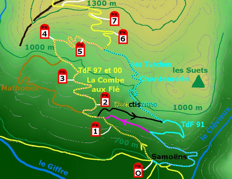
| Normal | ... natural coming from Taninges |
|
1st km crude (steep at 10% rate), 11.8 km | set up your gears "whole left" at the
bottom
of the pass,
recommended on market day (wednesday), |
| Chantemerle | ... pleasant |
|
branch East, goes through the village of Samoëns, goes below Chantemerle, goes by Les Turches, 12.4 km | to be avoided on market day
(wednesday),
for the climb: variant recommended as the easiest start, for the descent: to be avoided. |
| Directissima | ... sport | no : too narrow, bends too short | the shortest variant: 11.5 km,
- begins as "Normal" (look at the map below: black points on yellow track), - goes by Lachat - then finsihes as "Chantemerle" (look at black points on sky blue track). |
same than Normal |
| D354 (road #354 within the département) |
... institutional | no | goes through the village of Samoëns, way (itinéraire #36) proposed by the Departemental Council of Haute Savoie, kilometric points are painted on the ground (km 1), begins as "Chantemerle" (look at the map below: pink points on sky blue track), goes by Sous-Lachat then finishes as "Normal" (look at pink points on yellow track). | recommended for descent
(the origin of ground-painted distances is 200m after the village main place (PK0.4 for this site) |
| Mathonex | ... bucolic | no : too narrow | branch West, the most bucolic variant, 12.7 km | same than Normale,
to be avoided for descent |
A recommendation relevant to any of theses ways: be at the top before noon (10 or 11 am) to reduce risks of clouds on summits, Mont-Blanc itself included.
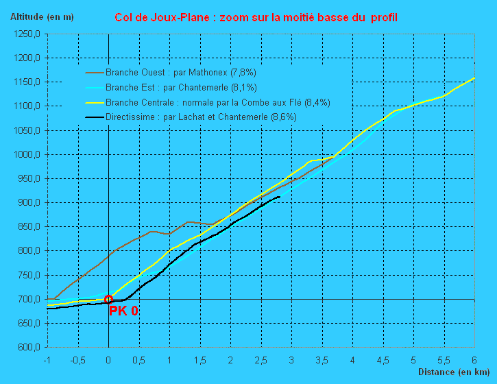
To look at the profile of each of the ways, click on this blue image:
To locate these ways on the map, click on this green image:
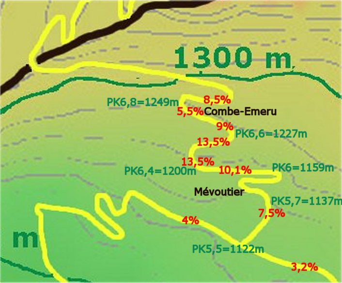
Do remember this area to avoid putting you "in the red": if the gear ratio was already too long during the previous slopes (at 10%), you will have to do zig-zags or go on walking ... until the end of the area to ride again the bicycle.
Respectively in 1997 and in 2000, Pantani and Virenque escaped for the win in this area (at the very same place: PK 6.5, photos). Armstrong got there in 2000 the unique failure (document) he has ever caught during a Tour de France.
One of the reasons is that the starting point of distances is not
posted
on the same place by each of them:
- reference to a monument: church, main place, castle,
- geographical reference: slope break of the access road in the valley
(case of this site),
- position such as the top of the pass finishes exactly with a full
kilometre (i. e. the length of the climb is, as a result, an integer
number
of km, case of Tour de France).
The table below shows, about the Normal way of Col de Joux-Plane, how averaged slope varies according to the position of the starting point of distances. Moving this position has as a result the shift of hectometers (100m) easy (or steep) from the km n to the km n+1.The slope-irregularity of Col de Joux-Plane makes this phenomena stronger.
Normal way of Col de Joux-Plane:
slope % per km
versus position of the origin of distances
|
|
||||||||||||
|
|
|
|
|
|
|
|
|
|
|
|
|
|
|
|
10,00 | 7,50 | 8,30 | 7,20 | 7,20 | 5,75 | 10,35 | 8,90 | 9,40 | 9,03 | 8,77 | 8,38 |
|
|
9,00 | 7,73 | 8,28 | 6,93 | 7,97 | 5,40 | 10,25 | 8,85 | 9,28 | 9,20 | 8,74 | 8,46 |
|
|
8,00 | 7,95 | 8,25 | 6,67 | 8,73 | 5,05 | 10,45 | 8,50 | 9,16 | 9,36 | 8,71 | 8,51 |
|
|
7,10 | 8,08 | 8,38 | 6,25 | 9,50 | 4,70 | 10,30 | 8,50 | 9,04 | 9,53 | 8,68 | 8,56 |
|
|
6,30 | 8,10 | 8,50 | 6,75 | 8,95 | 4,75 | 9,75 | 8,90 | 8,92 | 9,69 | 8,65 | 8,59 |
|
|
5,50 | 8,38 | 8,38 | 7,25 | 8,40 | 4,80 | 9,15 | 9,35 | 8,80 | 9,86 | 8,62 | 8,62 |
With power measured (under medical control, ECG under effort) of 175
W at 130 pulses / minute, it is :
- possible to hold 27 km/h on flat road alone for 2 hours (at the
beginning
of the cycling season, living at sea level),
- impossible to climb thoroughtly the Col de Joux-Plane after some
days of living there, even with a racing bicycle equipped of triple
chaining
on the front (weight cyclist + bicycle = 82kg).
To be able of more over 175 W does not let a leasure cyclist coming from sea level to climb thoroughtly the pass at the first trial.
After accustomed to efforts in mountains:
- it is possible to climb thoroughtly the pass in 100 mn including
6 minutes to stop (to drink without loss of breathe, because drinking
enough
prevent of breathing !), with the shortest gear: 30x24 almost from
bottom
to top, at steady 130 pulses / minute,
- the steepest area (13.5% topic above) may be
ridden with 30x24 (too long /
physical capacities) without zig-zags,
- performances in parisian district (sea level) are enhanced: the same
effort lets perform 31 km/h.
Besides, effort tests in shelter at atmosphere pressure = 5000 m high have proved, for various persons, that this elevation divides by 2 the power an used-to-hight person can run.
My conclusion is that for a given body effort, power available at sea level is very more than the one at 1000 m high (and, a fortiori, than the one at 2000 m), and this effect, I think, is proportionnal to the decrease of the atmosphere pressure. So at 700 m high (Joux-Plane bottom), pressure decrease -10%, power available -10% of the capability at sea level for the same effort.
Therefore, usual quotations of pass difficulty (called as well "estimated powers") seems to me too optimistic if they do not involve altitude: it is their cost to pay for the easyness of their calculus formula.
Parameter Irregularity
Applied to a pass with irregular slopes, quotations, usually based on slope averaged over a kilometre, are valid only for a cyclist equipped of gear which let him climb steepest hectometres (100, 200, 300m) than the km-average (and still clear-minded to use this right gear). Cyclist equipped of the gear just compliant with his/her physical resources versus the slope average will find more difficult a slope-irregular pass (maybe, will walk) than a constant rate one.
Oddly, economical importance of a pass is correlated to this
difficulty
criterion irregularity:
- small economical importance = few investment to improve roads =
laying
out fits closely the relief shapes = irregular slope,
- importance (to feed a significant resort, to link cities) =
investments
= banking up and cutting = steady rate.
This correlation is not so amazing since cyclist effort has the same
cause than vehicles (caravans, trailers, lorries) to go at a reasonable
speed at climb and to brake at descent.
Therefore, quotation should be given with the slope maximum, to assure cyclist of a climb without unpleasant and unexplained surprize. In default, interdiction to vehicles of more 3,5 t shows local slope(s) maximum very stronger than the slope average.
Conclusion
Harden yourself quotations without altitude taken into account.
Beware of small roads: get gear ratio lower than given by the
largest
km-averaged slope.